|
Development of Lake Okeechobee Environmental Model AEE is working on the development of Lake Okeechobee Environment Model (LOEM) for the South Florida Water Management District. Based on the Lake Okeechobee hydrodynamic and sediment model previously developed by AEE for the District, AEE is adding the water quality submodel, the sediment diagenesis submodel, and the submerged aquatic vegetation (SAV) submodel to the LOEM. Key model state variables include: carbon, chlorophyll, coliform bacteria, dissolved oxygen, silica, phosphorus, and nitrogen. |
|
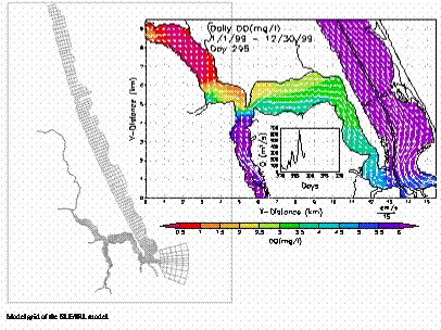
Development of Surface Water Management System in St. Lucie Estuary and India River LagoonAEE is working on the project of St. Lucie 3D Water Quality Model Development for the South Florida Water Management District. The surface water management system will serve as an analytical and management tool for developing Pollution Load Reduction Goals, determining the nutrient range in the SLE/IRL, and making regulatory decisions. The model grid contained 1161 horizontal grid cells and 6 vertical layers. The tasks include hydrodynamic, sediment, and water quality development, and applications of the calibrated and verified model to water quality management. The hydrodynamic and sediment model has been developed and calibrated. AEE is currently adding the water quality submodel, sediment diagenesis submodel, and the submerged aquatic vegetation (SAV) submodel to the St. Lucie and Indian River Lagoon model. Key model state variables include: organic carbon, chlorophyll a, coliform bacteria, dissolved oxygen, silica, phosphorus, and nitrogen. The model is using 10 years of water quality data (1991-2000) for calibration and verification. The calibrated and verified model will be applied to study a variety of water quality management scenarios, including sediment dredging options, light attenuation and the associated water quality parameters, distributions of SAV, and contaminant transport in the estuary. |
 |
|
|
|
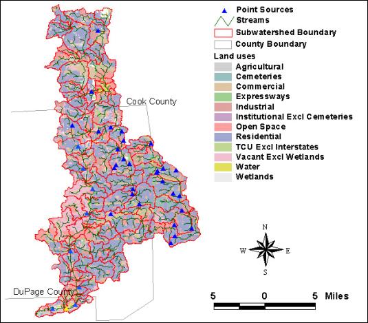
TMDL Development for Salt Creek, West and East Branch DuPage RiverAEE team members developed the Total Maximum Daily Loads (TMDLs) for the Salt Creek, the West Branch and the East Branch DuPage River in Illinois. These impaired waterbodies are located in urban Chicago area and were placed on Illinois 303(d) list for several water quality impairments including nutrients, fecal coliform, metals, chloride and suspended solids. The TMDL development tasks included acquiring available data, determining the data sets best suited for TMDL development, understanding the state of the watershed and its elements, and assessing all potential sources of stream impairments. The U.S. Environmental Protection Agency’s HSPF watershed model, Better Assessment Science Integrating Point and Nonpoint Sources (BASINS) analysis system, and in-stream water quality model QUAL2E were used to characterize the watershed and to evaluate TMDL allocations. The watershed models were calibrated using information from three United States Geological Survey (USGS) gages.
|
|
|
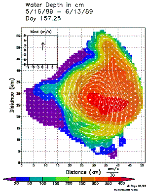
Hydrodynamic and Sediment Studies AEE developed the Lake Okeechobee Sediment Transport Model for the South Florid Water Management District. The model grid contained 2,126 horizontal grid cells and 5 vertical layers. The hydrodynamic calibration simulation included a predictive, dynamically coupled simulation of, temperature, and suspended sediment. The model is calibrated and verified using two sets of measured data, one set in 1989 and the other in 2000. Enhancements to the model include: 1) multi-year sediment bed model is developed and tested in the lake, 2) the wind wave modeling results from wind wave model (SWAN) are used in orbital velocity and bottom shear stress calculation, and 3) the computed bottom shear stress is applied for the sediment resuspension modeling to present the sediment deposition and resuspension processes realistically. The calibrated and verified model was applied to study a variety of water quality management scenarios, including water elevation change, light attenuation change, sediment deposition and transportation, hurricane impact of deposition and resuspension, and contaminant transport. |
|
|
|
|
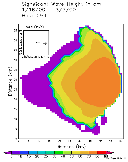
Wind Wave StudyTo simulate the wind-wave effects on sediment resuspension, AEE applied a spectral wind wave model SWAN (Simulation WAves Nearshore) to Lake Okeechobee. This model included the effects of refraction, shoaling, and blocking in wave propagation. It accounted for wave dissipation by whitecapping, bottom friction, and depth-induced wave breaking. The wave-wave interaction effect was also included in this model. Measurements of wind and wave heights were made at different stations and different time periods in Lake Okeechobee. Significant wave height values were computed from the recorded data. The correlation between wind stress and significant wave height also was analyzed. A six-day simulation using 1989 data was conducted for model calibration. Another six-day simulation using 1996 data was conducted for model verification. The simulated significant wave heights were found to agree reasonably well with measured significant wave heights for calibration and verification periods. Agreement between observed and simulated values was based on graphical comparisons, mean, absolute and root mean square errors, and correlation coefficient. Comparisons showed that the model reproduced both general observed trends and short term fluctuations. This wind wave model played a critical role in the later studies on sediment transport, water quality and eutrophication, and lake restoration planning. |
|
|
|
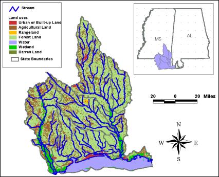
Watershed Modeling for Water Quality ConcernsAEE worked on identifying requirements and outlining a cost-effective approach for water quality modeling to satisfy several objectives of the Department of Marine Resources (DMR) Coastal Resource Management Program, Mississippi. AEE developed a modeling approach in order to help DMR coordinate their efforts with other state and Federal agencies. The modeling approach attempted to satisfy the following objectives: 1. The model should be useful to DMR’s Coastal Resource Management Plan (CRMP) in evaluating impacts to coastal fisheries from current and future land uses. In particular, the model should be capable of evaluating the effects of wetland loss and wetland restoration on water quality. 2. The modeling effort should be consistent with and take advantage of ongoing modeling efforts being conducted by Mississippi Department of Environmental Quality for the purpose of developing TMDLs. 3. The modeling effort should build on and be consistent with DMR’s current watershed and wetlands assessments and the GIS data used to support these assessments. 4. The modeling effort should be scalable to regional modeling of larger watersheds using a simpler approach to target other areas of potential water quality concerns. Potential parameters to consider include nutrients, dissolved oxygen, fecal coliform, sedimentation, pesticides and herbicides, and heavy metals. Potential sources of pollution include various land use practices, such as farming, animal feed lots, septic systems, timber practices, roads, construction, and development. |
|
AEE is currently working on a 3D hydrodynamic, sediment, eutrophication, and submerged aquatic vegetation (SAV) model in the Florida Bay. The model has been calibrated and verified against measured data from 1996 to 2002 for 7 years. The hydrodynamic model calibration focuses on the ability of the model to predict tidal, sub-tidal frequency sea level, currents, salinity, and temperature. Various quantitative approaches including harmonic and time series analysis are used to evaluate calibration as well a visual comparisons of model predictions with observational data. Two model grid configurations are also evaluated. The first configuration truncates the grid along the nominal coast line in North East Florida Bay, while the second configuration includes a large wet land region along the North East boundary of the Bay which dynamically interacts with open water regions.
|
|
|
For NOAA, AEE worked on the modeling of metals in the St. Lucie Estuary (SLE). This study was focused on the modeling of sediment and copper processes in the St. Lucie system and was based on previous hydrodynamic and water quality modeling studies of the SLE. The SLE copper model consists of four interrelated model components: 1) copper sources to the SLE, 2) hydrodynamic transport, 3) sediment transport, deposition, and resuspension, and 4) copper cycling in the water column and sediment bed. The developed model was applied to simulate the fate and transport of copper in the SLE. The modeling results were compared with available data in the area and were qualitatively consistent with the measured Cu data. The model was also applied to explain the Cu deposition patterns revealed in the measured data. An EFDC training was also conducted at the SFWMD. Trainees included representatives from NOAA, Florida Department of Environmental Protection, and SFWMD.
|
 |
|
 |
Aquifer Storage and Recovery Aquifer Storage and Recovery (ASR) is getting increasingly more popular in many countries of the world where excessive water is captured and injected into aquifers for future use. The success of an ASR system requires good knowledge of geology, hydrogeology and geochemistry of the site. Extensive studies are being conducted in order to understand the migration of injected "bobbles" so that better recovery rate could be achieved. |
|